Sunday, 13 May 2012

Applications of Technology in Planning

As with all fields, the advancement of technology has created many opportunities for the planning profession. One of the most important technological tools for a planner is Geographic Information Systems (GIS).

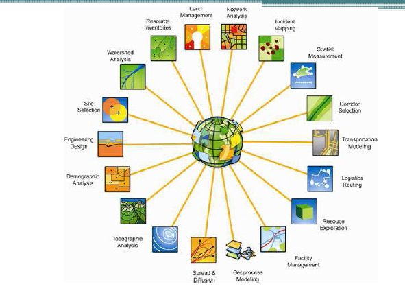
Applications of GIS
Source: Richard Nash 2012
GIS allows for the presentation of data about a particular area in a way that is meaningful and easy to decipher. Transport routes, disaster recovery and climate change risks are just some of the scenarios in which GIS provides invaluable assistance. The continued development of 3D technology in GIS will provide planners and the public with the ability to visualise the impacts of proposed development in a realistic way that is not possible using two dimensional representations.

GIS is not only a tool for professionals in the field, but one that can have great outcomes when used for Public Participation (PPGIS). The visual representation of information allows for members of the public to easily gain an understanding of the scope of proposed projects. When used in conjunction with the opportunity to provide feedback regarding developments, is an empowering tool for the public and useful tool for planners to gain an understanding of concerns.

Whilst the GIS is a commonly accepted technology in the planning process, other tools such as virtual globes are still relatively new and not widely used. Virtual globes are a model or representation of the Earth using 3D software. They have many benefits, namely: raising interest, awareness and access to issues by the public. For example, it is likely that the public will pay greater attention to information about the risks of climate change, if a visuals representation of a certain area is shown, with the impacts overlayed, giving a realistic view of potential harm. There are however, a number of drawbacks to the use of such technology, in particular, the potential for misinterpretation of information. There is the possibility for virtual globes to overemphasise issues, causing viewers to panic.

Like all technology, there are benefits and negatives, but if obstacles are overcome, virtual globes have the potential to revolutionise the planning process, and empower the public.

International Examples: Lessons for Australia

This week examples of planning in France, Germany and Cambodia were explored and ideas that Australia could benefit from were identified.


Paris, France

Paris, the city of love and lights, was remodelled between 1853 and 1870 by Georges-Eugène Haussmann under the orders of Napoleon III. The main aim was to 'modernise' the city, and allow it to cope with the growing pressures created following the industrial revolution. It has been described as being "the great work of breaking through the old city, of opening it to light and air, and of making it fit to sustain the army of merchants and manufacturers which makes Paris to-day the center of a commerce as wide as civilization itself."  The key feature of the plans was, of course, the impressive boulevards that Paris is now famous for. Although Haussmann's design had a much wider impact, giving inspiration to the City Beautiful Movement that remains visible in cities like Chicago and Canberra.


Lessons for Australia:

  • Emphasis on history and consistent character of areas to create sense of place
  • Innovative, environmentally friendly public transport

Lessons Australia Shouldn't learn:

  • Development on the Right Bank displays unflattering architectural styles and does not connect with the surroundings


Schwerin, Germany

With a population of just 100 000 people, Schwerin is Germany's smallest state capital. Despite having a population roughly one third the size of Canberra, Schwerin has a surprisingly large public transport system, consisting of 4 tram lines and 16 bus lines. Although this seems like an ideal situation, it would be interesting to find out how viable the current situation is and how it is funded. Perhaps Schwerin holds the secret of a successful transport system that Australian cities could learn from.....

Phnom-Penh, Cambodia

Phnom-Penh is the Capital of Cambodia, and has a population of 1 million people. Being located in SE Asia the impact of the wet season must be considered when undertaking planning decisions. After watching videos of traffic at intersections, it is clear that congestion is a major issue in Phnom-Penh. Tuk tuks are a popular mode of transport, leading to large numbers of vehicless on the road, as they only carry a limited number of passengers. The sheer volume of people on the roads leads to noise pollution from horns, impacting the quality of surrounding streets and buildings. Pedestrian safety was another issue identified. If the budget allowed, I think the introduction of buses and bus lanes would help reduce some of the congestion and noise pollution by allowing a large number of people to be transported at once.  

Phnom-Penh Traffic
Source: Oudam.com 2011