Sunday 13 May 2012

Applications of Technology in Planning

As with all fields, the advancement of technology has created many opportunities for the planning profession. One of the most important technological tools for a planner is Geographic Information Systems (GIS).

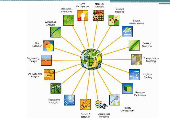
Applications of GIS
Source: Richard Nash 2012
GIS allows for the presentation of data about a particular area in a way that is meaningful and easy to decipher. Transport routes, disaster recovery and climate change risks are just some of the scenarios in which GIS provides invaluable assistance. The continued development of 3D technology in GIS will provide planners and the public with the ability to visualise the impacts of proposed development in a realistic way that is not possible using two dimensional representations.

GIS is not only a tool for professionals in the field, but one that can have great outcomes when used for Public Participation (PPGIS). The visual representation of information allows for members of the public to easily gain an understanding of the scope of proposed projects. When used in conjunction with the opportunity to provide feedback regarding developments, is an empowering tool for the public and useful tool for planners to gain an understanding of concerns.

Whilst the GIS is a commonly accepted technology in the planning process, other tools such as virtual globes are still relatively new and not widely used. Virtual globes are a model or representation of the Earth using 3D software. They have many benefits, namely: raising interest, awareness and access to issues by the public. For example, it is likely that the public will pay greater attention to information about the risks of climate change, if a visuals representation of a certain area is shown, with the impacts overlayed, giving a realistic view of potential harm. There are however, a number of drawbacks to the use of such technology, in particular, the potential for misinterpretation of information. There is the possibility for virtual globes to overemphasise issues, causing viewers to panic.

Like all technology, there are benefits and negatives, but if obstacles are overcome, virtual globes have the potential to revolutionise the planning process, and empower the public.

International Examples: Lessons for Australia

This week examples of planning in France, Germany and Cambodia were explored and ideas that Australia could benefit from were identified.


Paris, France

Paris, the city of love and lights, was remodelled between 1853 and 1870 by Georges-Eugène Haussmann under the orders of Napoleon III. The main aim was to 'modernise' the city, and allow it to cope with the growing pressures created following the industrial revolution. It has been described as being "the great work of breaking through the old city, of opening it to light and air, and of making it fit to sustain the army of merchants and manufacturers which makes Paris to-day the center of a commerce as wide as civilization itself."  The key feature of the plans was, of course, the impressive boulevards that Paris is now famous for. Although Haussmann's design had a much wider impact, giving inspiration to the City Beautiful Movement that remains visible in cities like Chicago and Canberra.


Lessons for Australia:

  • Emphasis on history and consistent character of areas to create sense of place
  • Innovative, environmentally friendly public transport

Lessons Australia Shouldn't learn:

  • Development on the Right Bank displays unflattering architectural styles and does not connect with the surroundings


Schwerin, Germany

With a population of just 100 000 people, Schwerin is Germany's smallest state capital. Despite having a population roughly one third the size of Canberra, Schwerin has a surprisingly large public transport system, consisting of 4 tram lines and 16 bus lines. Although this seems like an ideal situation, it would be interesting to find out how viable the current situation is and how it is funded. Perhaps Schwerin holds the secret of a successful transport system that Australian cities could learn from.....

Phnom-Penh, Cambodia

Phnom-Penh is the Capital of Cambodia, and has a population of 1 million people. Being located in SE Asia the impact of the wet season must be considered when undertaking planning decisions. After watching videos of traffic at intersections, it is clear that congestion is a major issue in Phnom-Penh. Tuk tuks are a popular mode of transport, leading to large numbers of vehicless on the road, as they only carry a limited number of passengers. The sheer volume of people on the roads leads to noise pollution from horns, impacting the quality of surrounding streets and buildings. Pedestrian safety was another issue identified. If the budget allowed, I think the introduction of buses and bus lanes would help reduce some of the congestion and noise pollution by allowing a large number of people to be transported at once.  

Phnom-Penh Traffic
Source: Oudam.com 2011


Monday 30 April 2012

Planning for Adaptation: Eurobodalla Shire

As the Mayor of Eurobodalla Shire Council (in this week's round table role play), I would like to present the following summary of issues discussed in this week's meeting to the public.


Attendance:
  • ACT Chief Minister
  • NSW Premier
  • Council Planner at Eurobodalla Council
  • Local restaurant owner
  • Local resident
  • ACT resident and Batemans Bay holiday house owner
The coastal zone is one of Australia’s greatest assets, and a vital part of the Australian way of life, as stated by Holliday in 1998, “Everybody wants access to the coast. The … coast is where people want to live, do business, create development and where people want to recreate” (CoastalCRC 2006). The natural beauty and proximity to major cities makes the South Coast a popular domestic tourist destination, particularly for those living in the ACT. There are, however, many challenges faced by coastal towns and cities (such as Batemans Bay) which are summarised in the diagram below.  


Climate Change poses a serious threat to coastal areas, not only through the risk of sea level rise and erosion, but bushfires as well. There are three main strategic planning options to deal with climate change associated factors include:


  • Planning
  • Mitigation (defending existing sites)
  • Planned Retreat

Taking into consideration climate change risks when planning any new developments is the most effective option (cheapest, socially desirable). However, the idea of limiting development in vulnerable areas often conflicts with developers desires to capitalise on lucrative water front locations. Mitigation and planned retreat both raise many  issues regarding responsibility and funding of land- public or private funding? Such issues have been tackled in Byron Bay, where a lawsuit was filed against the Council by owners of a beach front property that was damaged from erosion (http://www.smh.com.au/nsw/residents-step-up-action-against-byron-council-and-sue-over-beachfront-property-dispute-20110110-19l7r.html). In order to prevent such occurrences here, Eurobodalla Council should encourage forward planning in relation to climate change, and promote community awareness of the risks to private land owners.
Areas at Risk from Sea Level Rise


One of the major factors hindering the successful management of the coastal zone in Australia is the fragmented nature of governance, “In Australia, coastal management is fractured by commonwealth, state, regional and local government responsibilities and there is no coordinated coastal legislation or coastal policy but rather a complex mix of legislation, plans and policies” (CoastalCRC 2006).


I believe that further support from both the State Government and ACT Government would greatly help Eurobodalla Shire address the current problems facing the community, that were raised in this meeting today by our local residents. The Council will aim to collaborate with other local Councils, in the hope of forming a regional alliance to help tackle the challenges faced by our communities. In Victoria, the Geelong Regional Alliance provides an example of a regional body that has achieved positive outcomes due to collaboration. Regional bodies lend themselves to strategic planning and management of complex trans-boundary issues, so the creation of one in the South Coast is a major priotiry.

Molonglo Development

The current development of Molonglo was discussed this week, with a presentation from one of the Engineers involved in the project. The parameters of the development in terms of the ACT planning framework were discussed, with issues such as maintaining the integrity of the Y-plan and remaining compatible with the Spatial Plan and Territory Plan highlighted. The Molonglo site was chosen as it possesses the qualities of both urban capable and urban suitable land- meaning it is not only physically able to support development, but in a socially and economically responsible manner (largely due to proximity to existing infrastructure and services).

The presentation highlighted the diversity of issues that must be considered when undertaking such development, including: environmental impacts, transport capability, water supply and the concerns of the community.

One of the main concerns raised by those in surrounding areas was, of course, additional traffic and congestion created by increased population in the area. The modelling related to such traffic increases suggests that the resulting traffic on connecting roads will be within acceptable limits. In terms of public transport, Molonglo is conveniently located to provide a stop between Belconnen, the City, Woden and Weston Creek. Perhaps the 'filling in' of exiting transport hubs will help increase the use of existing routes, and lead to increased frequency and improving the overall transport network in Canberra.

Proposed Bus Routes for Molonglo
Source: ESSD 2010
One of the points raised during discussion was that of community consultation in relation to the project. As previous blog posts have mentioned, community consultation is an integral part of the planning process, however, in the case of Molonglo, there are no existing residents so the stakeholders are mainly those in surrounding areas.

Sunday 29 April 2012

Urban Redevelopment: Docklands, Melbourne

Docklands 1871
Source: Destination Docklands 2012
The Victorian Planning Model was further explored this week, with the redevelopment of Docklands used as an example. Since the late 1880's the area served as a major port for the city of Melbourne, until the 1970's when it was left abandoned as a result of changes to cargo transportation methods.


It was underutilised until the 1990's, when the Dockland's Taskforce was directed to identify the best options for the development of the area. In 1991, the Docklands Authority Act was passed and the Dockland's authority established to help facilitate private development of the area.
Docklands 2010
Source: Trip Advisor 2010 
Currently VicUrban (Victorian Government's Sustainable Development Agency) is responsible for leading the development, which is being undertaken in partnership between the Government and private sector (PPP).


The importance of fostering relationships between these two sectors has been highlighted throughout this semester. Often the public sector has limited resources, so the implementation of proposed plans and projects poses a challenge, so partnerships with private companies increases the economic viability of developments.


The $12 billion waterfront development of Docklands provides an example of a suc cessful PPP that has benefited all stakeholders in the area, as the statistics below illustrate.


Source: VicUrban 2010

The development of Docklands corresponds nicely to the ideas expressed in the Melbourne @ 5 Million Report. In particular, the notion of creating multiple city centres to cater for population growth and "increasing levels of housing and employment in established areas close to where people reside, particularly where the tram network can support this level of change" (Department of Planning and Community Development 2008). Docklands fits these criteria with it's proximity to the CBD, existing integrated road network (linkage to main streets such as Collins and Bourke Street) as well as the location next to Southern Cross Station.  


As Australia's largest construction project, and a large urban renewal project by world standards, substantial community engagement was undertaken, lasting over 12 months. After reviewing the Docklands: The First Decade Report, it seems that the development has been successful in transforming the underutilised land into a mixed-use, vibrant community. It's likely that with continued development, the area will become an integral part of the city of Melbourne.

Local Planning in Victoria

The topic of this week's class was local planning in Victoria, particularly focusing on the city of Melbourne as an example. Local governments play a key role in the planning process, making the majority of planning decisions that affect their jurisdiction.


Although Melbourne has been nominated as one of the world's most liveable and Australia's favourite cities, it still faces many challenges, particularly in relation to population growth and climate change. The main strategic planning documents that address such issues include: Melbourne @ 5 Million and Delivering Melbourne's Newest Sustainable Communities- both of which have a heavy emphasis on connected transport options and green design.


Population Growth Poses a Problem for Melbourne
Source: The Age 2011


A presentation by Rob Adams (Director of City Design for Melbourne) discussing the steps that transformed the city into the vibrant city with a thriving public life that we know and enjoy today was watched in the second half of the lesson. One of the key aspects of the revitalising of Melbourne was the focus on the public spaces. Many of the ideas outlined by Adams corresponded to those of Jane Jacobs- the creation of good streets to make a good city and taking into account the natural landscape and assets of the city and capitalising on them. One of the first projects undertaken was reconnecting the city with the Yarra River, which now a vital part of the city, providing a variety of public spaces enjoyed by locals and tourists.
Southbank Melbourne
Source: DJB World Photography
As an aspiring planner, many tips were taken from this presentation. In particular the idea of embracing the natural assets and history of a city, recognising the importance of smaller scale projects (like public art) to enhance sense of place and encouraging developers to consider active frontages and architectural diversity for lively streets. But perhaps most importantly, the idea that through the use of seemingly simple planning, design and development guidelines, wonderful cities like Melbourne can be created.

Wednesday 4 April 2012

Canberra Planning

The first part of this week’s class focused on Canberra’s planning history, and really highlighted the unique nature of Canberra, as Australia’s only fully planned city as shown by the following quote, “Canberra achieves the difficult feat of being one of the last cities beautiful. And also the World’s biggest Garden City”. Although Canberra and the planning processes that have shaped the city have been criticised by some, an interesting point was raised about what the Nation’s Capital would be like without the foundation of Griffin’s plan.

After focusing on Canberra’s planning history, it’s interesting to think about the current and future direction of planning in the city. This week COAG released a Review on Capital Cities Strategic Planning Systems (http://www.abc.net.au/news/2012-04-02/cities-fall-short-of-the-mark-on-planning3a-report/3926318). Each of the city’s planning systems was rated against nine criterion, including areas such as: integration, hierarchy of plans, capital city networks. Canberra rated reasonably well in most areas, however, the need for increased integration between ACT planning and NSW planning was raised as an area in need of attention. In particular, improving transport links between Queanbeyan and the ACT was identified as a priority and after recently visiting Queanbeyan Council and discussing issues facing the area it seems that such measures would have many benefits, particularly since so many Queanbeyan residents commute to Canberra for work each day.

The second half of the lesson focused on the redevelopment of the Belconnen Town Centre and involved a short walk around the area. After the $2.4 million spent on road works and $100 million spent on upgrading the mall, we noticed many positive features, but also room for improvement. The Emu Bank area along the Lake, with its wide walkways and shade providing trees, offers an inviting recreational area for those living and working in the area.
Source: LJH Commercial, 2012

One of the main negative aspects of the development is the disconnected nature of the shopping mall to the Lake. As the picture below shows, the mall exists in isolation and does not interact with the street, despite the prime location on the Lake front. Charles Landry, a renowned planner visited Civic in 2010 and commented on the way that shopping malls ‘suck the energy’ from their surroundings. He also stated that redevelopment projects are too often considered separately, and need to be integrated in order to create vibrant places (http://www.abc.net.au/news/video/2010/11/12/3065333.htm?site=canberra&source=rss). Although he was talking specifically about Civic in this interview, similar aspects can be seen in Belconnen. If the side of the mall closest to the Lake was developed with linkage to the Lake in mind, with active street frontages such as cafes, and glass windows instead of a car park and bare walls, it is likely that both the mall and lakefront would enjoy increased use.  
Source: Wikipedia, 2011

Thursday 29 March 2012

Local Planning in Queanbeyan

This week's class further explored the topic of local planning frameworks, with a field trip to Queanbeyan City Council to hear about the new planning framework recently introduced by the NSW local government. One of the key aspects of this reform was the replacement of separate plans with an integrated framework. The idea is to provide consistency between various statutory planning processes and reports and strengthen the strategic focus of councils. Planning takes place at many levels, over various time frames, and with many parties involved, thus to maximise efficiency and effectiveness integration is imperative.

Heirarchy of Queanbeyan Plans

The heirarchy with different temporal scales for each document is a key feature of integrated planning, and allows for the pursuit of long term goals through the undertaking of projects in the short term. Whilst this planning approach seems ideal in theory, one of the issues identified by the presenter at Queanbeyan was the failure to integrate the former Social Plan into the new documents. As a LGA, Queanbeyan faces challenges presented by factors such as a growing population and proximity to Canberra leading to decreased business opportunities. Thus, an emphasis on social planning issues is important to manage the liveability of the area. Another issue raised during discussion was the limited resources and power of Local Councils. The new planning documents are of little use if the measures are not able to be implemented. Although the Operational Plan identifies budget issues and practical aspects of implementing projects, there still seems to be a gap between the actual ability of Councils to put actions into practice.

Source: Queanbeyan City Council Delivery Progam, 2009

Sunday 4 March 2012

Local Level Planning Framework

This week's presentation focused on the Planning Framework at a local level, and was delivered by Hamish Sinclair, Director of the Planning Institute of Australia. Although perhaps a little overwhelming in terms of volume of information, having a solid understanding of the framework under which we may work is imperative.

After exploring The Codes Project website (http://codesproject.asu.edu/), it is evident that the idea of codes and laws relating to urban form is not new, with examples of building codes on the site dating back to the 10th century. Many of these early codes have a strong focus on security measures like city walls and trenches, and tend to have a prescriptive planning approach with an abundance of measurements relating to height and width of buildings etc. Today, this focus on details and measurement is still important, however, there has been a shift away from prescriptive planning to performance based planning. This shift aims to encourage diversity and creativity in urban design so as to avoid the creation of areas like that pictured below.

The Victorian Coastal Council's Siting and Design Guidelines (http://www.vcc.vic.gov.au/siting/sitingdesignguidelines.pdf) provide an example of a set of guidelines that have a strong emphasis on place making and urban design. Whilst this style of planning guidlines and codes are positive in the sense that they enhance the character and sense of place within areas, the detail required to convey information without simply using statistics leads to lengthy documents.

A Monotonous American Suburb
Source: Word Press 2010

Another important (and perhaps disconcerting) point raised was that regarding the difficulty of actually implementing plans in a market based society. The idea that one can create great plans, but their effectiveness is restricted by economic viability and will of developers. This concept is highlighted by the actions of great planners such as Ebenezer Howard, who placed great emphasis on the self sustainable economy of his garden cities, but had to make significant changes to his ideas when actually implementing the plan. Although disheartening to hear that as professionals, our plans, no matter how wonderful, are unlikely to be fully implemented in the way we desire, it just demonstrates the importance of taking into consideration economic viability when they are created. Instead of looking upon this as a negative, it is simply another challenge in the already multi-faceted skill set needed to be a successful planner.

Monday 27 February 2012

Who is Involved?

The idea of communicative planning has been touched upon in previous blog posts, and was further explored this week through discussion about various stakeholders in the planning process. As planning has progressed from a physical exercise in which plans were perscribed, involvement of stakeholders has become an essential part of the profession.
Examples of Stakeholders- residents, Government, business owners, users of public transport
Sources: Golden Acts 2012, Logopedia 2012, SMH 2008, Waikato Regional Council 2011 


Various levels of participation were identified, ranging from the provision of information (not truly a form of participation) right through to supporting independent stakeholder groups to enable them to take action. Each of the levels posess benefits and negatives, and are suited to different situations.

The idea of involving stakeholders as much as possible in the planning process is noble, however, challenges are often faced in reality. When talking to those in the profession, a common complaint I've come across is that public consultation events are organised but often have few attendants. This leads to feelings of wasted time by the organisers, and often results in complaints by stakeholders when planning action occurs as they state they haven't been consulted. This is an inefficient outcome, and frustrating for all parties involved.

It's likely that communities with higher levels of social capital are more inclined to have higher participation rates in planning decisions, as social capital is linked to sense of pride and interest in the community. This presents a catch 22 situation though, because often the proposed plans that are under consultation outline measures that will lead to increased social capital.

An interesting idea brought up in class was that of workshops organised and planned by students in Japan. Perhaps the introduction of such measures in Australia would be helpful. Residents may feel less intimidated by students, and more likely to attend consultation events. There is also the added bonus of creating links between universities and the local community.

Sunday 26 February 2012

What kind of Plans?

This week's class explored the hierarchy of plans related to the ACT, and they way in which they interact to provide our current planning framework.


As would be expected, the documents at the top of the hierarchy provide a general vision, and less specific detail. The subsequent plans provide further detail specific to certain areas, that must comply with and build upon the ideas outlined in these guiding documents. 

It can be seen that there are many different plans related to the area, each with a different style and purpose. Whilst having so many different plans serves a purpose, it must be ensured that they are all integrated without having repetitive information.

The presence of different layers of planning also has the potential to cause conflict. This is particularly apparent in Canberra, which has the added agency, The National Capital Authority responsible for areas considered of importance to the city as a Capital (Parliamentary zone, Lake Burley Griffin etc). This inevitably has the potential not only to cause overlap within planning documents, but conflict between the NCA and other planning bodies. Such fragmentation causes delays and inefficiency, so the integration and constant review of planning documents is essential to ensure effectiveness of the system. Bodies such as COAG are instrumental in undertaking such activities.

Welcome Back for 2012

After a break over the summer holidays, it's time to get back to blogging as part of the second Planning Theory and Process unit. Enjoy, and feel free to leave comments!